


Folding
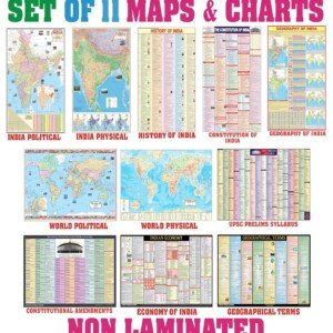
India & World Map ( Both Political & Physical ) with Constitution of India, Indian History, Indian Economy & Geographical Terms Chart
₹199.00
Unlock Your Success in UPSC, PCS, SSC, Railways, and More with Our Comprehensive Maps & Charts Set!
Prepare to excel in the most challenging competitive exams with our all-in-one Maps & Charts Set, tailored to meet the rigorous demands of UPSC, PCS, SSC, Railways, and beyond.
✍ This edition includes-
1. India Political Map
- Size: 70×100 cm
- Contains essential details about India’s political divisions, capitals, and major cities
2. India Physical Map
- Size: 70×100 cm
- Depicts India’s diverse topography, including mountains, rivers, and plateaus
3. World Political Map
- Size: 70×100 cm
- Provides a global perspective on political boundaries, countries, and capitals
4. World Physical Map
- Size: 70×100 cm
- Explore the world’s physical geography, including continents, oceans, and mountain ranges
5. The Constitution of India Chart:
- Size: 58×90 cm
- Contains the entire Constitution of India for quick reference
6. History of India Chart:
- Size: 58×90 cm
- Highlights key events and historical timelines of India
7. Economy of India Chart
- Size: 58×90 cm
- Presents vital economic data such as GDP, sectors, and economic policies
8. Geographical Terms Chart
- Size: 58×90 cm
- Defines essential geographical terms and concepts
✔Please note- These maps are NON LAMINATED but printed on high quality paper with sharp and easily readable text.


Reviews
There are no reviews yet.